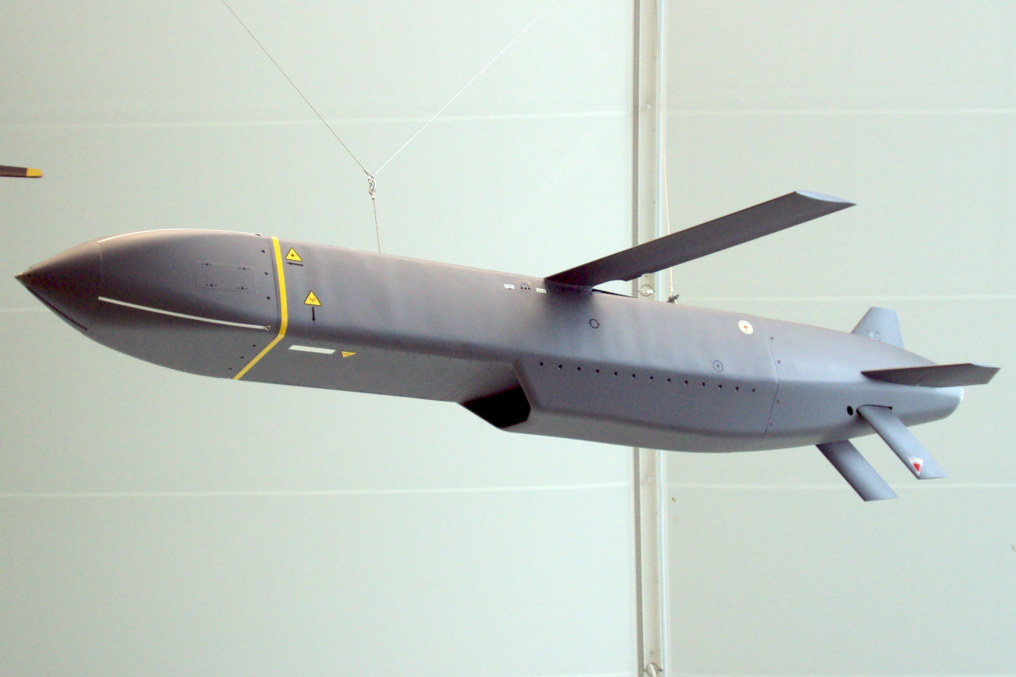
THE TRUTH ABOUT STORM SHADOW TARGETING
There has been much chatter about who programs the Storm Shadow (and Scalp) missiles for Ukraine and who fires them. It has been stated incorrectly many times that the US has to be involved and that only they can provide the data necessary for their use. This is incorrect; here are the facts.
Manufacture Of SS and Scalp Guidance Systems
These are manufactured by MBDA Systems a consortium owned by Airbus, BAE Systems and Leonardo. These missiles use a hybrid system for their guidance not just GPS:
-
Inertial navigation system (INS) principle guidance system
-
Military grade GPS for mid-course correction and calibration of the INS
-
TERPROM - Terrain Profile Matching to allow low level radar avoidance flight.
-
Imaging - Infra red for terminal guidance AI scene matching
The components used in these MBDA Systems are sourced from the UK, France and US, but it is MBDA Systems that integrates these into the functional systems. It is not a US company.
The break-up of the manufacturers of the components is:
-
Imaging Infrared (IIR) Seeker: Manufactured by Leonardo (specifically their Precision Guidance business in Basildon, UK). This seeker provides the "eye" for the terminal phase, matching live images against pre-stored target data.
-
Terrain Reference Navigation (TERPROM): Originally developed by British Aerospace, this system is now part of the Atlantic Inertial Systems portfolio (a subsidiary of Collins Aerospace/RTX). It uses a radar altimeter to "read" the ground and compare it to digital maps.
-
Inertial Navigation System (INS): Historically provided by companies now under the Safran Electronics & Defence umbrella (specifically former Sagem or Thales navigation units). These systems use high-precision gyroscopes to track the missile's position without external signals. Bog standard INS as used by all commercial heavy aricraft.
-
GPS Receiver: Typically sourced from Collins Aerospace or Honeywell, these military-grade receivers are designed to resist electronic jamming. The GPS systems are more accurate than consumer systems. This accuracy is produced by using a much longer pulse compression sequence for the cross correlation of the raw GPS signal as well as other features such as system duplication, redundancy and better RF front ends.
If the GPS system is jammed the inertial guidance system will continue navigating the missile albeit with reduced accuracy. The GPS system is used pre-launch to set the initial position of the INS just as in commercial passenger jets.
These high grade GPS systems are also used on passenger jets for Precision RNAV guidance.
- Radar Altimeter: Often supplied by Thales, which allows the missile to maintain a "terrain-hugging" low altitude to evade radar detection. Bog standard as used in every commercial heavy aircraft.
It is worth noting that all of these systems are used by the modern Airbus fleet except for the Terrain mapping and terminal guidance systems. Airbus does have a similar system for terrain avoidance, but it is not designed for terrain following.
Programming Of The Systems
Programming these systems involves two main steps:
1. Programming the flight path, i.e. Latitude, Longitude and Altitude where altitude may be GPS referenced or radio altimeter referenced depending on the flight phase. Very similar to programming the flight path of a modern Airbus or Boeing, waypoints, interpolations. limits etc.
2. Programming the terminal guidance data, images of target etc. Not required for civilian flight.
The programming of these systems is carried out by authorised military personnel using proprietary mission planning hardware and software.
Authorised Personnel
The authority to physically program the missile and its flight path is restricted to:
Military Mission Planners: Highly trained specialists from the operating air force (e.g., UK Royal Air Force, French Air and Space Force).
Specialised Intelligence Officers: Personnel responsible for processing the classified cartographic and imagery data required for the missile’s terrain-matching (TERPROM) and terminal seeker (DSMAC) systems.
Technical Specialists (MBDA): While military units handle operational programming, MBDA engineers provide the underlying software environment and may assist with complex integration or system refreshes.
International Oversight: Because the missile often relies on US-owned GPS and terrain data, the US Government maintains oversight under ITAR (International Traffic in Arms Regulations), which can restrict who is authorised to handle certain high-level mission data.
All of this equipment, the procedures and processes are classified as military secrets. Ukrainian personnel would not have this authorisation and in fact would need years of training to carry out this work.
The US has authority over who can use their data and equipment, but it need not be involved in every missile launch.
Key elements of ITAR include:
Scope: Covers defence articles, services, and related technical data, including military hardware, software, and intelligence technologies.
Purpose: Ensures sensitive technologies do not fall into the hands of unauthorised foreign entities or rogue nations.
Compliance & Registration: U.S. manufacturers, exporters, and brokers of defence items must register with the Directorate of Defence Trade Controls (DDTC) and comply with licensing requirements.
Foreign Person Rule: Transferring technical data to a foreign person, regardless of location, is considered a deemed export to that person's home country.
Exemptions: Recent changes have introduced exemptions for some, such as the AUKUS defence pact partners (Australia, UK).
So the British have full autonomy over Storm Shadow deployment.
US Role In Storm Shadow Deployment
To minimise the risk of interception the flight paths of the SS's is programmed to avoid Russia air defence systems. Real-time US Satellite data would be intrinsic to this. Given the close cooperation between the British and USA they are both in the NATO alliance it is unlikely that such data would be withheld from the British and in fact I would suggest the British have complete routine access to it within the command centre.
Do the British Fire Storm Shadows Without the Knowledge of the US
Lets us look at the facts:
-
The war in Ukraine is between NATO and Russia
-
There is a command centre in Wiesbaden Germany to coordinate the NATO campaign.
-
Autonomous, independent action by any of the NATO members without consultation with NATO command could cause significant negative consequences for the overall campaign.
-
To avoid friendly fire participants need to know what the others are doing.
-
The consequences of a misstep by NATO could be that Russia might misconstrue a NATO action as an existential threat and launch a nuclear strike.
Conclusion
My conclusion is that the is very little likelihood that the British and French launch Storm Shadows and Scalps without involving the other participants and that all participants would be involved in the planning of these missions to a greater or lesser degree. The idea that Britain just wakes up one morning and decides to attack the Kerch Bridge without telling anyone else is absolute nonsense.
However, it is the British who program the flight paths and targeting images into the Storm Shadows, and they don't need the Americans involved other than in the planning stages within NATO command. The flight path satellite data of the US is provided without any American authorisation. This data is simply an element of the overall NATO situational awareness in the command and planning centre.
Whether it is a Ukrainian who pushes the button to launch is immaterial it is a NATO attack on Russia. It is planned by NATO, programmed by NATO and the Ukrainian is told when to push the fucking button. If it looks like a duck, walks like a duck and quacks like a duck it is NATO. And the British elites are up to their eyes in it.